
Newfoundland is a huge, beautiful wonderland of natural scenery and fantastic trails. Not surprisingly, the many great hikes in St. John’s NL and the surrounding area draw plenty of outdoor lovers in summer. One of the main reasons we went to Newfoundland was to check out as many of the spectacular St. John’s hikes as possible.
There is a wide range of terrific Newfoundland trails located up and down the coast of the Avalon Peninsula not far from the capital city. Originally, my thought was to hike the entire length of the East Coast Trail but a combination of unreliable spring weather and unreliable enthusiasm from my hiking partner ended that thought.
Our site includes affiliate links to products we recommend. If you use one to make a purchase, we earn a small commission at no extra cost to you. Thanks for your support!
However, we also really enjoyed exploring the city and many of the interesting spots nearby. So avid hikers will obviously want to visit Newfoundland to try some of the top hiking trails around St. John’s and elsewhere on the peninisula but, rest assured, there is plenty more to keep you busy as well.
Quick Links
East Coast Trail
336.5 km / 15-25 days / 15,000m elevation gain
AllTrails: https://www.alltrails.com/trail/canada/newfoundland-and-labrador/east-coast-trail–3
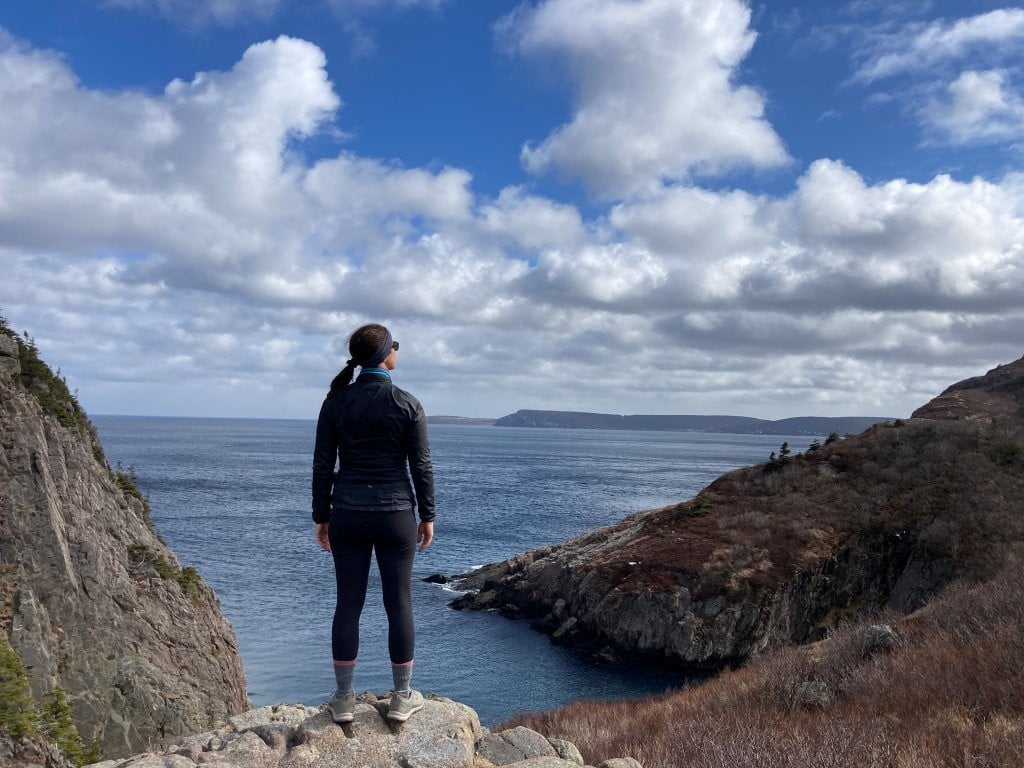
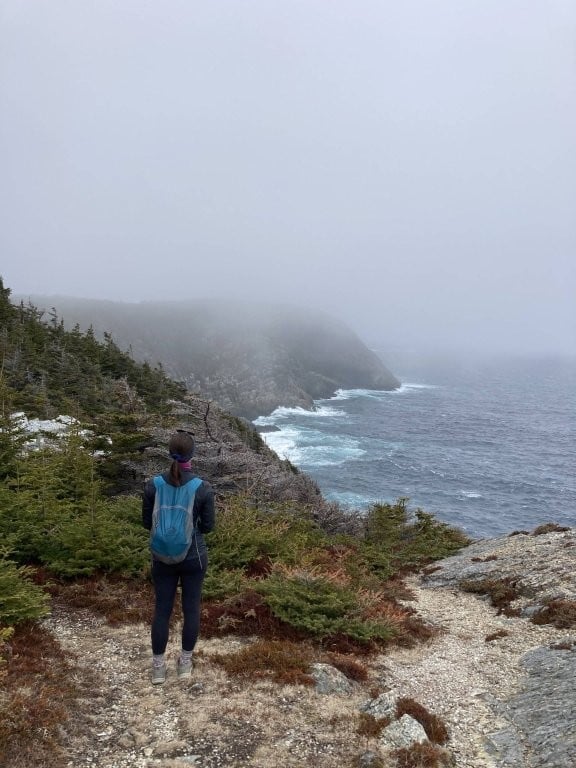
The East Coast Trail is one of the most famous long-distance hikes in Canada, known for its amazing coastal beauty and convenient accessibility. And maybe just a bit for its erratic weather…
Most thru-hikers complete the entire thing in around 3 weeks, although it is quite easy to simply hike one section at a time. Despite less than ideal weather during our time in St. John’s, we were still able to try out a lot of the best St. John’s hikes, including many sections of the East Coast Trail.

The Best St. John’s Hikes – Organized by Difficulty
Some of the hikes in this list are loops, some are one-way trails, and some are intended to be one-way trails but we just hiked the partial trail and returned the way we came. If you have two vehicles – or a friend who wants to join you – on a lot of the hikes it makes sense to leave one car at the end of the trail so you can drive back to the trailhead when you’re done. Or you can book a taxi to serve the same purpose.
There are several different taxi companies in and around St. John’s and here is another we didn’t use but saw advertised at a couple trailheads:
Southern Shore Taxi & Tours
(709) 334-3662
If you need to rent a car, we usually go with Discover Cars. We’ve used them around the world and they’ve always been efficient and reliable and often have the best selection and prices.
The trail details are length / estimated hiking time / total elevation gain. Difficulty ratings are chosen based on trail conditions – steep climbs and descents, terrain, etc. – not length (that part you can decide on for yourself). Also, within the descriptions for the Moderate and Difficult hikes we have often outlined shorter versions that can be done if you are low on time (or energy).

The rankings take into account both the trail itself and the views along the way. Some, such as the Bell Island Sea Stacks, aren’t much of a hike but have a spectacular view. Others, like Topsail Beach, are more about the interesting trail.
Either way, though, the specific order could easily change daily depending on the weather or our mood. But this list of our St. John’s hikes should at least give you a general idea of which ones to prioritize.
Best Easy Hikes Near St. John’s
1. Signal Hill Loop
6 km / 2 hrs / 280m
Easy
There are many different trails on Signal Hill and you can start from just about anywhere as well. Down by The Battery, up top at Signal Hill National Historic Site itself, or down on the other side by Cuckold Cove.

The version in this map is the longest alternative and hits all the highlights (Ladies Lookout, North Head trail, Burma Road) but you can easily break it into different sections at different times.

2. Quidi Vidi Harbour Viewpoint
1 km / 30 min / 25m (return)
Easy
A short, easy climb to a couple of different viewpoints of Quidi Vidi harbour and Quidi Vidi Brewing Company. The views to effort ratio are excellent.

This can actually be part of the Sugarloaf Path, although there is a slightly shorter variation of that ECT stage that skips it.
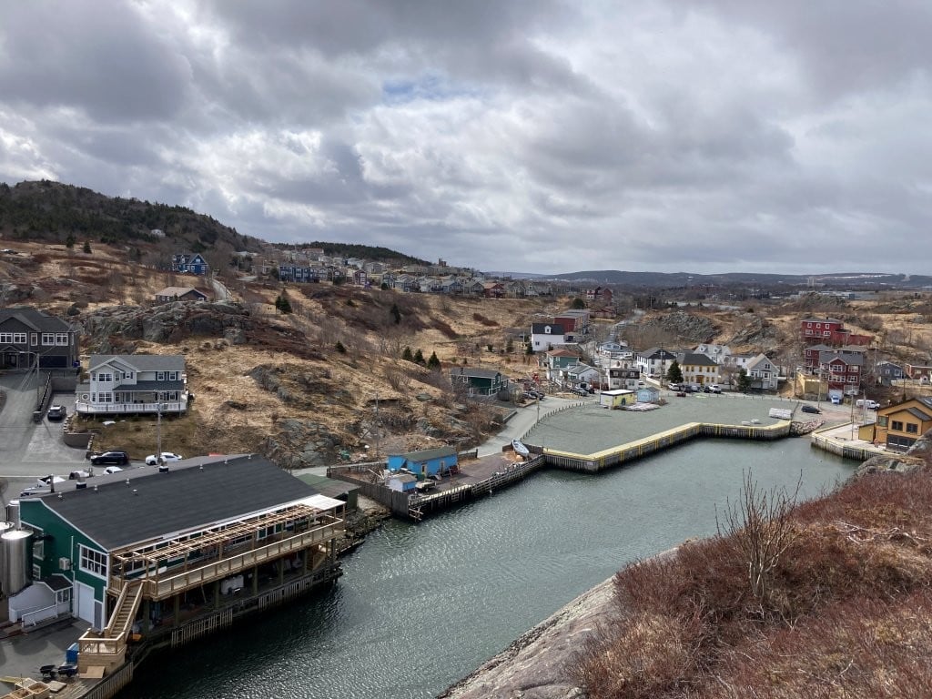

If you are just looking for the harbour viewpoint, though, I would recommend adding another 15 min up/10 min down to continue up to the Sugarloaf Harbour Viewpoint. The scope is just much larger.

This viewpoint made our list of 10 Best St. John’s Photo Spots.
3. Bell Island Sea Stacks
3 km / 1 hr / 100m
Easy
AllTrails: https://www.alltrails.com/explore/trail/canada/newfoundland-and-labrador/bell-island-sea-stack
While not strictly “in” St. John’s, these spectacular formations just off the coast of tiny Bell Island are the highlight of any visit to one of the best day trips from St. John’s. There are a couple of sea stacks, including “The Bell” (although we personally didn’t see the resemblance), which is apparently where the island got its name.

Based on the viewpoint alone this would rank higher but the walk is less a hike and more an easy and relatively flat stroll on a dirt road through some grassy fields. You can branch off to the edge of the cliffs at several different points along the way.

If you have a high-clearance vehicle and no issue with removing barriers, you can actually drive down fairly close to the best viewpoints. Although we assumed there was a wire across the road entrance for a reason, on our way back we were passed by a couple driving down in a big truck. Either way, our rental Camry wouldn’t have loved that road…
Ferries go back and forth between Portugal Cove and the island every hour or so. The schedule changes a lot so it is best to call (709) 895-6931 for a recording of the latest info.
4. La Manche Village Hike
4.5 km / 1. 5 hrs / 140m
Easy
Official AllTrails GPS:
https://www.alltrails.com/trail/canada/newfoundland-and-labrador/la-manche-village-path
My AllTrails GPS that includes Doctor’s Cove and the longer walk from the actual parking area:
https://www.alltrails.com/explore/map/la-manche-village-path-b618c32
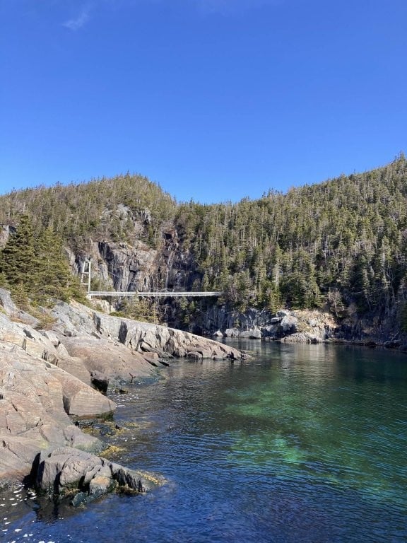
About an hour drive from St. John’s, this is a pleasant, mostly shaded walk through trees where you won’t have scenery very often but when you do, it is pretty impressive. The rocky outcroppings at Doctor’s Cove (1 km from start) are well worth the short, 5-minute detour. Then the La Manche Suspension Bridge, with the river below, the waterfalls behind and the views over the bay are all outstanding.

There isn’t much left of the abandoned La Manche village except some concrete foundations but the surroundings more than make up for it.
5. Topsail Beach Miner’s Trail
7.5 km / 2-2.5 hrs / 160m
Easy
This is the official starting point and first stage of the East Coast Trail, rather ironically since it is actually on the west side of the peninsula. Topsail Beach is vibrant and popular in summer, rather bleak and desolate in April, but the trail is nice and fairly unique.

Unlike those on the east side, there are lots of roots among the trees along this gently up and down path that is sheltered from the sun and wind most of the time. In some sections the lower branches of the pine trees are bare and grey, occasionally looking like a sinister cluster of skeletons.

If you are only up for a shorter option, you can go as far as you like before turning back or set your sights on the beach cave about a kilometre in.
6. Bowring Park Loop
4 km / 1 hr / 200m
Easy
AllTrails: https://www.alltrails.com/explore/trail/canada/newfoundland-and-labrador/bowring-park-loop
Definitely the most surprising hike we found right in St. John’s. Despite being in the centre of the city it features trees, ponds, bridges, a river, waterfalls and grassy areas.

There are also lots of path options – you can stick to the very smooth gravel path or venture off into the trees closer to the river. There are also lots of different variations to choose from along the way.

7. Long Pond Loop
3 km / 45 min / 50m
Easy
AllTrails: https://www.alltrails.com/explore/trail/canada/newfoundland-and-labrador/long-pond-loop
Pippy Park, across from the hospital, has a nice variety of trails to choose from. The Long Pond Loop is a simple, scenic route around the lake/pond starting at the Fluvarium.

The AllTrails map shows an elevation gain of 130 metres but I can’t imagine that’s right – it is basically a flat trail.

8. Octagon Pond Loop
4 km / 1 hr / 100m
Easy
A straightforward, flat exercise walk on a wide gravel path around a small lake in the St. John’s suburbs. It is mostly sheltered but more exposed on the north side so choose your walking direction based on the wind.

9. Quidi Vidi Lake Loop
4 km / 1 hr / 50m
Easy
AllTrails: https://www.alltrails.com/trail/canada/newfoundland-and-labrador/quidi-vidi
A simple, exposed trail that circumnavigates Quidi Vidi Lake (created by a dam). It isn’t as nice as the hikes in and around Quidi Vidi Harbour but is still a nice walk on the right day.

It is famous for strong winds so try to pick a (relatively) calm day.
Best Moderate Hikes Near St. John’s
1. Silver Mine Head Path
4 km / 1.5 hrs / 150m (return)
Moderate
AllTrails: https://www.alltrails.com/trail/canada/newfoundland-and-labrador/silver-mine-head-path
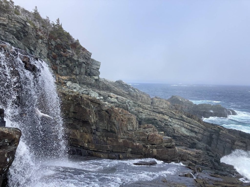
First day, first hike, and also one of the best. It helped that we got a gorgeous, sunny day, of course, but whatever the weather, the scenery from this trail is stunning. Much of it is sheltered in the trees where there was still some melting snow and muddy patches, but that also meant a bunch of small waterfalls from the snowmelt.
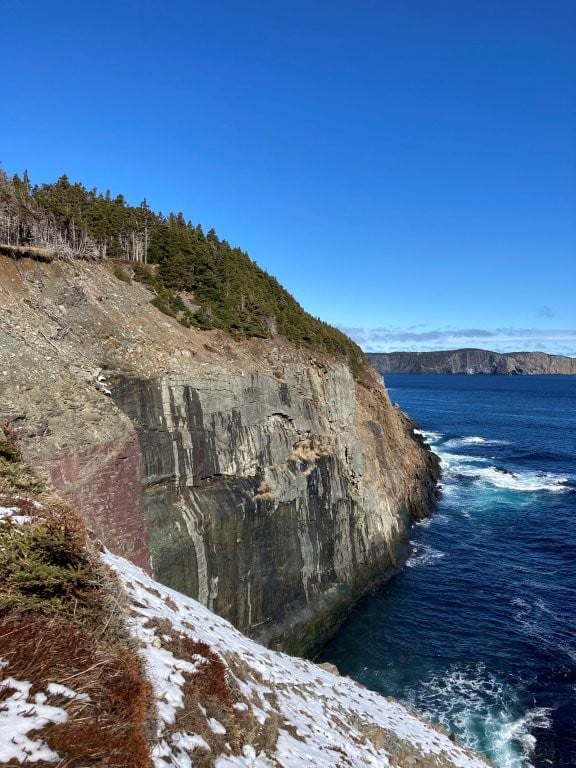
It starts from beautiful Middle Cove Beach and goes to the edge of the village of Torbay, where you’ll find expansive views of the bay from an open hill (and even a couple of the iconic Canadian red chairs).

This hike is already pretty short but if you want just a quick stroll or have kids with you, just a short distance into the hike you’ll find a set of fascinating rocky tidepools where you can make your way from rock to rock. There is also a tiny bridge across a small stream with multiple little waterfalls below.
2. Cape Spear to Maddox Cove
5 km / 1.5 hrs / 150m to Little Jones Cove (return)
9 km / 3 hrs / 280m to North Head (return)
12 km / 4 hrs / 230m to Maddox Cove (one-way)
Moderate
AllTrails: https://www.alltrails.com/trail/canada/newfoundland-and-labrador/maddox-cove-to-cape-spear
Two of the most iconic sites in St. John’s are the Cape Spear Lighthouses (one old and one new), which are certainly worth visiting even if you aren’t planning to hike (the road ends right below them). The views both of and from the lighthouses are terrific, then you can make your way along the superb cliffs with amazing coastal views the entire way.

Since it is an out and back hike you can go as far as you want before turning back, although we would definitely recommend making it at least as far as the hill at Little Jones Cove.
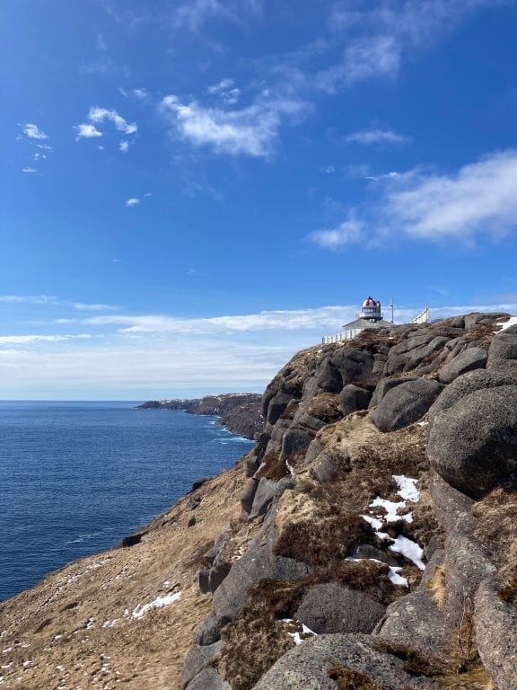
If you have two cars you could leave one at Maddox Cove and hike the whole thing just one-way. Or you could get a taxi back to your car at Cape Spear.
3. Biscan Cove Path
13km / 4-5 hrs / 700m (return)
Moderate
AllTrails: https://www.alltrails.com/explore/trail/canada/newfoundland/biscan-cove-path
This is one of the best stages on the East Coast Trail and the map above details the entire return trip. The exceptional trail alternates between trees and rocky vantage points, with one very good viewpoint right at the start, then another one every kilometre or so.
The area around Freshwater River is particularly beautiful, with tremendous views, big rocks and multiple waterfalls. People looking for a shorter walk could to the falls and back (5.5 km) in around 2 hours.
If you want to see the whole thing, though, you can go there and back, or a second vehicle would let you turn it into a 2-3-hour one-way hike. A third option is to hike out along the coast and back along the more direct and much faster road, reducing the overall hike to 10-11 km and 3-4 hours.
4. Fort Amherst to Freshwater Bay
10 km / 3-4 hrs / 510m (return)
Moderate
AllTrails: https://www.alltrails.com/trail/canada/newfoundland-and-labrador/fort-amherst-to-freshwater-bay
Even if you don’t do the hike (or just do part of it), it is worth driving to see Fort Amherst and enjoy great views of the harbour. On the way out to the fort you’ll come to Battery Lookout (our name) on a corner with a dock and several fishing boats – this is one of the best places for iconic fishing village views across the bay.

The trail itself goes from Fort Amherst along the ridge next to the coast and continues to Freshwater Bay – this map shows an out and back version. However, it is also possible to walk all the way to Cape Spear if you have the time, energy and a ride back (14 km / 5 hrs / 610m).

5. Cuckold Head
1.5 km / 45 min / 50m
Moderate (very steep section at the end)
AllTrails: https://www.alltrails.com/explore/trail/canada/newfoundland-and-labrador/cuckold-head
Just over the hill from Quidi Vidi you’ll find some nice viewpoints of Cuckold Cove close to the road or, for an even more impressive look at the area, tackle this simple but steep climb to the top of Cuckold Head.
It is pretty easy at first, taking you past another good angle of the cove to the south, then it gets fairly steep (and occasionally slippery) on the last climb to the top. There are a few ropes that look far too old and frayed to be counted on but it should be manageable even without them.

From the top you have great views in both directions (including Quidi Vidi harbour) and there is a handy sheltered spot between some large rocks where you can enjoy a snack out of the wind.
Note: on Google Maps they incorrectly show Cuckold Head on the far side of the harbour.
6. Mickeleen’s Path
12 km / 3-4 hrs / 700m
Moderate

One of the few loop options along the ECT, the Mickeleen’s between Bay Bulls and Witless Bay lets you enjoy excellent coastal scenery on the first half before returning via a flatter and more direct (also somewhat less scenic) inland route.
Best Difficult Hikes Around St. John’s
1. Sugarloaf Path
8 km / 3 hrs / 720m
Difficult
AllTrails: https://www.alltrails.com/trail/canada/newfoundland-and-labrador/sugarloaf-path/
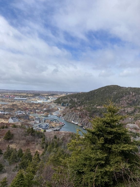
Probably the most well-known section of the East Coast Trail, the iconic Sugarloaf Path starts or ends at the colourful little fishing village of Quidi Vidi, a popular destination in its own right. Between the panoramic views of Quidi Vidi harbour at that end and the rugged cliffs around Logy Bay at the other end, Sugarloaf has some truly incredible scenery.

Of course, it is also harder than most of the coastal trails (or any of the trails around here, for that matter). Like most of the East Coast trails it is constantly going a little bit up, a little bit down, repeat. Except on Sugarloaf the climbs and descents all seem a bit longer – 15 minutes a time instead of 5, for example.
So you’ll feel it by the end, for sure, especially if you walk all the way to the end and back. We did it as a one-way hike by leaving our car in Quidi Vidi and taking a taxi to the Ocean Sciences Centre at the other end, then hiking back. We hadn’t thought about it ahead of time but were lucky to have the wind at our back. On days when the coastal winds kick up (as they often do) you might want to use that to plan your direction.

Anyway, the effort was well worth it for some of the best views around St. John’s. Plus, although there are nice viewpoints all the way along, the best bits are definitely at either end so if you were looking for a shorter option you could easily settle for 1.5-2 hrs return from either end and still walk away pretty pleased with your day.
2. Spurwink Island Path
16-18 km / 5-6 hrs / 750m
Difficult
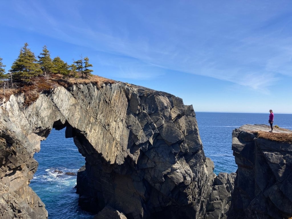
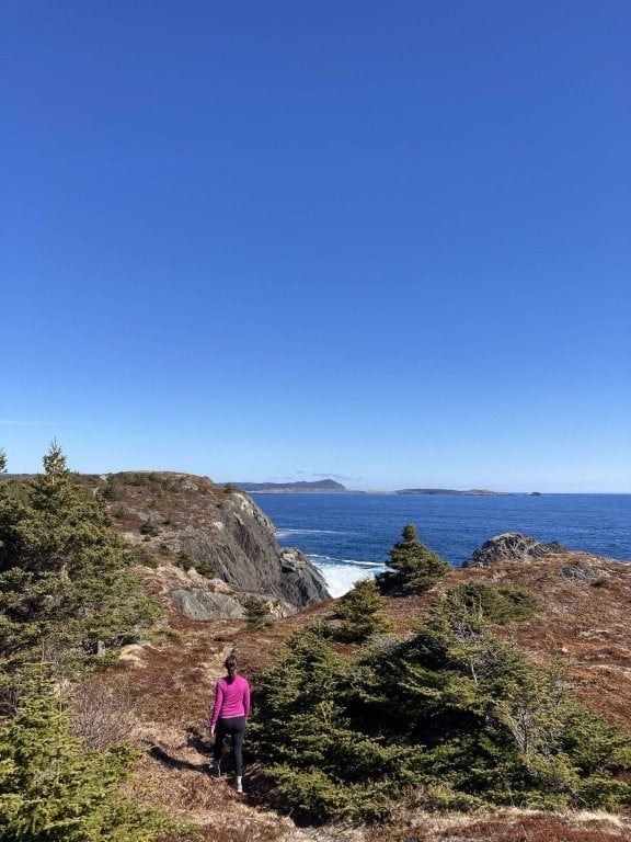
The longest, most difficult hike we did around St. John’s, the Spurwink Island Path also had the most memorable payoff. Berry Head Arch is truly spectacular – if you could drive there it would be one of the most popular tourist spots in Newfoundland.
Alas, you cannot drive there. In fact, the closest you can get is 8 km away in either Port Kirwan or Aquaforte, leaving you with a very scenic but fairly difficult hike. The trail is pretty straightforward at either end but gets progressively rougher, wilder and muddier the closer you get to Spurwink Island and Berry Head Arch.
So, whether you take a second car (or taxi) to one end or hike in and out from the same side, you’re facing at least 16 km of relatively tiring trails to earn your photo op.
From Port Kirwan, you have 15 minutes along a quiet dirt road, then a nice easy path with outstanding views to Grassy Point (approx. 1 hr). Just here and back is a good choice if you aren’t up for the entire hike but still want to see this beautiful area.
After Grassy Point, the scenery is still excellent but the trail gets worse and worse with mud and fallen trees until you reach Berry Head Arch (thank you, Hurricane Larry). Then you have to decide if you want to add 1 km each way to the Spurwink Island viewpoint (although you can actually see the island from the very end of the arch, as well).
From the Aquaforte side, the trail is crappier and the scenery isn’t as good but you pass Spurwink Island on the way to the arch, saving yourself that extra detour.
3. Flatrock Cove to Stiles Cove Path
16 km / 5-6 hrs / 1,000m
Difficult
Many of the best parts of this ECT stage come right at the start so it is once again possible to shorten it if you choose. You start out over some fascinating rocks at lovely Flatrock Cove where, if you’re anything like us, you’ll probably get delayed watching the crashing waves.

Next up is Big River which, according to the very helpful information board, was named this because of its size. Shocking stuff, I know. Although in some ways it is shocking because, in the scheme of rivers, this one is actually kinda small. In our personal opinion.
Anyway, it still features a variety of different waterfalls and a nice wooden bridge. Then you head into the trees, eventually making it to the top of the high rocky point visible from the very start (45-60 min) where you get exceptional views in both directions – north to Stiles Cove, south to Flatrock Cove.

This is a good place to turn around if you’re looking for an easier hike. If not, you will continue in around the bay, alternating between trees and cliffside views.
4. Spout Path
22 km / 7-9 hrs / 1,100m
Difficult
“The Spout” – a dramatic blowhole in the rocks – joins Berry Head Arch and La Manche Suspension Bridge as the most iconic images from the ECT. The downside is that the shortest route in and out is still 22 km (some say it ends up being more like 25 km). Add in over 1,000 metres of total elevation gain and you’re in for a really long day. Which is why a lot of people do it as an overnight camping trip.
5. Flamber Head Path
11 km / 3-4 hrs / 700m (one-way)
Difficult
Considered one of the most scenic ECT stages, the Flamber Head Path runs to La Manche Suspension Bridge from the south, opposite the La Manche Village Path. You can leave a vehicle just inland from the bridge or utilize a taxi, otherwise this becomes another 22 km journey.

However, coming from Brigus Road, there is a good viewpoint at about the 4 km mark if you want to try a shorter in and out hike.
St. John’s Trails Map
Click the star to save this map to your Google Maps – then find it under Saved/Maps (mobile) or Your Places/Maps (desktop)

Trip Planning Resources
Here is a list of the most important resources we use when planning our travels, all in one convenient spot. Full disclosure, when you use any of these links to reserve or sign up for something, we receive a small commission which is greatly appreciated. However, your price does not change and we have only included products and websites that we can honestly recommend.
- We book the majority of our hotels on Booking.com. With frequent stay discounts, thousands of reviews and free cancellation, it is very rare for us to have a bad hotel experience these days.
- Wise is by far the best international multicurrency bank account we’ve found. We can now send and receive money in half a dozen different currencies, convert to dozens more with no exchange premium and pay or withdraw local currencies. Highly recommended.
- When travelling we always get SIM cards with data for our phones. Local SIM cards are sometimes a bit cheaper but if you have a relatively new smartphone (iPhone XR or newer, Samsung S20 or newer) you can just buy an eSIM online, get a QR code by email and you’re good to go. After extensive research we have found that Nomad eSIMs usually have the best coverage and prices.
- Google is currently transitioning to an AI-only model and are now actively suppressing private websites. In most cases, they don’t even share attribution links to show where they got their information. Legal theft, apparently, which is terrible for travel blogs, as well as people who actually use travel blogs for trip research (i.e. us) rather than just hoping the latest AI mashup is somewhat accurate. Anyway, the point is, if you still want to read firsthand travel information, we recommend using DuckDuckGo as your search engine. You might even find some delightful Routinely Nomadic posts ranking high in those results.
- If you’re interested in local guided tours, including everything from city tours to cooking lessons to adventure activities, check out the huge range of options at Get Your Guide.

Summary
Known more for its brightly coloured buildings, seasonal icebergs and eager drunks getting “screeched in”, the hiking in St. John’s doesn’t get nearly enough attention. There are dozens of fabulous St. John’s hikes within an hour of the city, most of which feature incredible coastal views (maybe including some icebergs and whales if you’re lucky).
So, whether you are looking for an easy stroll or a demanding coastal adventure, you should be able to find the perfect St. John’s trail to match your mood.
Pin it for later!
Other Posts You May Be Interested In:
12 Easy Hikes in North Vancouver
The 10 Best Hikes Near Canmore
7 Amazing Drumheller Hiking Trails
Grasslands National Park: Big Sky Hiking, Camping and Wildlife
Mulagljufur Canyon: One of the Best Day Hikes in Iceland
About the Author
Dean Johnston

Dean Johnston quit his job as a financial planner in 2008 to travel the world, and has now visited all 7 continents and more than 85 different countries. He wrote his first blog entry in a sweltering internet cafe in Bali in 2000 and has been writing about their travels ever since, including publishing 3 travel books.
As Routinely Nomadic, Dean remains focused on providing informative travel guides, entertaining stories and useful social media content to readers from all over the world.
The East Coast Trail would have been fun, but what can ya do?! I run into the same issue with my hiking partner. Beautiful looking hikes though. Thanks for sharing!
We’ll see, maybe another time we’ll do the whole thing but yeah, that coast is pretty spectacular. Glad you enjoyed the photos.