
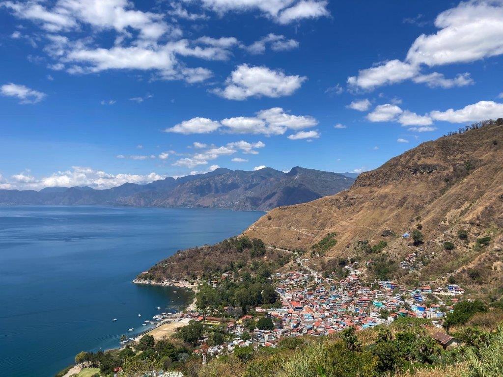
The best thing about spending extended periods of time on beautiful Lake Atitlan is the scenery, although you don’t necessarily need months to enjoy the main highlights. I mean, it just happens to be a stunning crater lake surrounded hills and volcanoes that looks amazing from every angle. The second-best thing about it, however, are all the amazing Lake Atitlan hikes. There is great hiking on Lake Atitlan, with trails scattered along ridges all the way around, offering unique combinations of views, village life and rural charm.
For everything you need to know before visiting Lake Atitlan, check out our:
Our site includes affiliate links to products we recommend. If you use one to make a purchase, we earn a small commission at no extra cost to you. Thanks for your support!
Ultimate Guide to Lake Atitlan

Hiking is one of the best things to do on Lake Atitlan partially because the lake sits at over 1,500 metres above sea level and never gets as hot as most of Central America. Of course, this also means it may take a bit of time for your body to get used to the altitude.
Unfortunately – or maybe fortunately, if you relish the opportunity to avoid the crowds – trails in Guatemala are notoriously difficult to hike independently. Trail markings are non-existent, many pass confusingly through farmer’s fields and small villages and a few of them have a disappointing reputation for robberies.
However, with the helpful descriptions, some GPS assistance and the occasional guide, there is no reason you can’t tackle many of these great Lake Atitlan hikes during your visit to this iconic Central American destination. While we have narrowed it down to our 6 favourites for those with a limited amount of time, we have also included all the details for 20 more hikes around the lake for those settling in for longer stays.
Since we always stay on the north side of the lake at Pasaj-Cap Rentals (between San Marcos and Tzununá), many of the hikes are shown starting from there. The estimated hiking time includes short breaks but excludes any transportation to or from the trail – keep in mind, this will vary considerably depending on your personal fitness and speed.

Any GPS links are to Wikiloc files. Wikiloc is a hiking app that is free to join and features hiking trails all over the world. Once you have the app installed and an account set up, when using your phone just click on the link in a browser (i.e. Chrome, Safari) and it should automatically open in the Wikiloc app.
If you prefer a different trail app (All Trails and Maps.me are two popular ones) it is possible to download the actual GPX file out of Wikiloc. From there you should be able to import it into your app of choice.
You can follow the individual links in each description to the specific Wikiloc files or you can browse the entire list at:
https://www.wikiloc.com/wikiloc/user.do?id=2996888&event=favorites&listId=67888
Happy trails!

The 6 Best Lake Atitlan Hikes
1. Mayan Trail
Distance: 10km
Elevation Gain: 500m
Time: 2.5-3 hrs
Difficulty – Moderate
Officially this hike goes between Santa Cruz and San Marcos, although the Wikiloc map only shows the stretch from Tzununá to Santa Cruz. This is by far the most scenic section, although if you want to start (or finish) in San Marcos, you simply add 3km (45min) on the dirt road between the two villages (which barely qualifies to be called that).

When it comes to hiking on Lake Atitlan, this is by far the most popular independent hike on the lake (most people use a guide to climb Volcán San Pedro), and for good reason. Sometimes also called the Mayan Ridge Hike, after you pass Lomas de Tzununá (the hotel high up on the hill) it is all single-track along a ridge high above the lake with outstanding views the entire way.
Unlike many of the other trails, it does not involve any particularly slippery sections, although there are a couple of steep spots. It is the perfect length and difficulty for a nice morning hike with lots of good lunch choices waiting at either end. Many people shorten it and stop in Jaibalito specifically to eat at Hans’ Place (officially called Posada Jaibalito), reducing the total by 2km and 30 minutes.
Robberies, unfortunately, do take place on this trail so if at all possible you should hike in a group (even 3 or 4 should be enough) and avoid carrying valuables. Sundays, in particular, have a bad reputation (young guys off work and drinking? It’s a theory).

Having said that, however, we do this hike at least once a week and have never had any problems personally. Usually we are in a group, but I would say that Laynni and I have done it alone at least 50 times without incident, and I have often jogged it alone as well.
So don’t be scared off, just be smart, and don’t carry a bunch of stuff that makes you look like a target. This is the one hike on Lake Atitlan that every able-bodied walker should try.
https://www.wikiloc.com/hiking-trails/santa-cruz-tzununa-lake-atitlan-22075066
2. Flower Route
Distance: 6 km
Elevation gain: minimal
Time: 2 hrs
Difficulty: Easy
A relatively recent addition to the list, this easy but spectacular downhill Lake Atitlan hike starts at the pleasant but fairly unknown village of Godinez. From there it is almost all downhill to the lake without ever getting particularly steep as you cut diagonally across the slope down to beautiful Santa Catarina Palopo.
We call it the Flower Route because as you get close to Santa Catarina Palopo (possibly the most picturesque village on Lake Atitlan) you pass through sets of farm terraces, some of which are filled with colourful, photogenic flowers. These are the same flowers you’l see in markets all around the lake.
Even before fantastic Santa Catarina and the wonderful terraces, however, you will enjoy incredible panoramic views of the lake in all its glory. All while barely breaking a sweat. Which is why it has become one of our favourite Lake Atitlan hikes and a steady member of our hiking rotation.
Colectivo minibuses from Panajachel to Godinez (15Q/pp, 30-45 min) can be found on a little side street near the market (just tell the tuk tuk driver you want to go to Godinez – they know the spot). The first 2 km from Godinez follows a main road but it is very quiet and has a few good viewpoints along the way.

Then you reach the stunning Mirador Montenegro and venture onto smaller roads and, eventually, a dirt trail. If you want to shorten the hike you can hire a private shuttle to the mirador (I think we paid 150Q once with a group of 6 but those prices can change by the minute so be ready to haggle).
And if you want to extend the hike further, you can walk the straightforward 4 km from Santa Catarina Palopo to Panajachel, although this road is much busier and not so pleasant on foot. An easier option is to hop in the back of a pickup for 5-10Q per person.
https://www.wikiloc.com/hiking-trails/the-flower-route-godinez-to-santa-catarina-palopo-124348917
3. Long Ridge Hike – Santa Clara to San Juan
Distance: 10km
Elevation Gain: 200m
Time: 2.5-3.5 hrs
Difficulty: Moderate
Other than the Mayan Trail, this is probably our favourite hike. It is the longest version from Santa Clara to San Juan (the Short Ridge Hike is up next) and, while the overall amount of downhill is similar, the grade isn’t quite as steep.

We normally take a tuk-tuk from San Marcos to San Pablo (10q each), then ride in the back of a pickup (or in a minibus) up the steep switchbacks from San Pablo to Santa Clara (5-10q each). From there you walk through town and out on a tiny paved path past the cemetery.
Then you’re on the road briefly for a bit of a climb, before crossing the fields of an avocado farm (keep your distance from the buildings and the dogs that guard them) to a wildly picturesque ridge overlooking the lake and volcanoes. At the end of the ridge the trail splits. You take the right fork (the left leads down to San Juan on the Short Ridge Hike) for a short but steep climb through the trees to a new set of fields.

After that you follow an undulating trail through fields, forest and past several more viewpoints before joining up with a dirt road that leads off to nearby villages, including Panyevar. Then we leave the road for another 1-hour descent into San Juan, but one that is slightly less steep than the Short Ridge Hike and through a different valley with close-up views of Volcán San Pedro.
4. San Antonio Palopo – Santa Catarina Palopo
Distance: 9 km
Elevation Gain: 560m
Time: 2.5-3 hrs
Difficulty: Moderate
This exceptionally scenic hike is one of our favourites and one of the few Atitlan hikes that blends a reasonable uphill climb with a gentle descent (so many are steep in one direction or the other). It starts with a tiring 500m climb out of San Antonio, then heads across through some picturesque fields and lovely valleys to Mirador Montenegro where it meets up with the Flower Route we talked about earlier. From there it is just a pleasant, gradual downhill walk to Santa Catarina Palopo.

While the climb out of San Antonio is significant, the trail is generally wide and smooth (along with stairs in the steeper parts). Meanwhile, the views include a good look back over San Antonio Palopo, beyond to San Lucas Toliman and further yet to Cerro de Oro and the three volcanoes. Towards the end you get fantastic views north along the shoreline with the colourful buildings of Santa Catarina backed by steep, scenic hills.

You can get to San Antonio from Panajachel by pickup or tuk-tuk (30 min) and the hike starts beside the main church with an uphill walk through town.
https://www.wikiloc.com/hiking-trails/san-antonio-palopo-santa-catarina-palopo-high-route-128538580
5. Rostro Maya (Indian Nose)
Distance: 6km
Elevation Gain: 950m
Time: 3-4 hrs
Difficulty: Strenuous
Rostro Maya is the politically correct term, although this geological anomaly is still most commonly known as Indian Nose, in reference to the shape of the hill. However, understandably, some people find that name offensive. Rostro Maya, on the other hand, means “Mayan Face”, which doesn’t really avoid the whole nose shape comparison but does avoid the word “Indian”, I suppose.

Anyway, it is a very popular hike out of San Juan, particularly for sunrise. While it doesn’t finish as high as Volcán San Pedro and doesn’t take nearly as long (roughly 2 hrs up, 1 hr down), I personally found it a bit harder because it is more exposed to the sun, whereas San Pedro is mainly in shade. Of course, this would not be as much of an issue if you hike up very early in the morning. Our 7:30 am hike was (shockingly!) much easier than the time I went up at 10 am.
It costs 30Q for entrance to the park and there is a very popular (and colourful) viewpoint about 15 minutes into the hike. If you don’t take a guide you will probably get stopped again later and asked for additional fees by enterprising farmers along the way. The first mirador is about halfway to the nariz and was free (or at least unguarded). Then the next mirador is just off the trail after a low saddle where we “coincidentally” ran into a farmer just as we arrived who said it was 25Q to enjoy that one.

Of course, there are a number of spots along the trail before this with fantastic views as well so it’s very possible to simply hike up to the saddle (1.5 hrs) and back down (1 hr or less) and only pay the initial 30Q.
https://www.wikiloc.com/hiking-trails/rostro-maya-san-juan-la-laguna-25197409
It is also possible to book a guided sunrise tour where you get a ride to near the top, then just have a short 45-minute walk up to the viewpoint.
You can read our detailed guide here: The Nariz del Rostro Maya Sunrise Tour

6. Volcán San Pedro
Distance: 9.5km
Elevation Gain: 1,200m
Time: 4-5 hrs
Difficulty: Very Strenuous
A rite of passage for many of the backpackers that come to San Pedro, it is one of the most accessible volcanoes in Guatemala. As with most volcanoes, it involves a long, steady climb followed by the same route back down, so hiking times will vary considerably depending on your fitness. I know a guy who got to the top in an hour and a half and others who struggled up for over 5 hours. 3 hrs up and 2 hrs down is the typical conservative estimate, however.

The hike is in a protected park with an entrance fee of 100q. While this is a bit pricey, it does include a guide (although you can opt to go alone if you or someone with you already knows the trail). Bear in mind that most of the hike is in the trees so you only get views at a mirador about an hour in, then at the top. So it is best to start as early as possible (it usually opens at 8am) because there are usually fewer clouds in the morning.
I have done it three times. Twice we enjoyed amazing views from the top but once we were completely shrouded in and couldn’t see a thing. Also, like the San Marcos-Santa Cruz hike, there have been reports of robberies in the past. Having a guide should take care of that problem but it is worth asking around to find out the current situation.
https://www.wikiloc.com/hiking-trails/volcan-san-pedro-lake-atitlan-23017085
More Easy Atitlan Hikes
Short Ridge Hike – Santa Clara to San Juan
Distance: 7 km
Elevation Gain: 100m
Elevation Loss: 700m
Time: 2-2.5 hrs
Difficulty: Easy

This hike follows the same route as the Long Ridge Hike from Santa Clara for the first part but at the end of the ridge, when the trail forks, you take the left option which leads through the trees for a couple minutes before heading steeply down to San Juan for roughly an hour. While this hike is “easy” when it comes to effort, the steep descent could be difficult for some.
Santa Clara – Panyevar Ridge Hike
Distance: 7km
Elevation Gain: 200m
Time: 2-3 hrs
Difficulty: Easy

This is another alternative for those with knee issues or if you simply don’t like hiking downhill for extended periods. You get to enjoy the same ridge views and moderate ups and downs of the Long Ridge Hike but then skip the downhill by staying on the dirt road to the little village of Panyevar. From there you can catch a bus or minibus back to Santa Clara and beyond.
https://www.wikiloc.com/hiking-trails/santa-clara-la-laguna-panyevar-lake-atitlan-22668319
Parque Chuiraxamolo – Santa Clara
Distance: 7 km
Elevation Loss: 700m
Time: 2 hrs
Difficulty: Easy
One of the most popular Lake Atitlan viewpoints is located just outside the entrance to Parque Chuiraxamolo and is a place you may have passed if taking a shuttle or bus down to San Marcos or San Pedro. The mirador is free but it costs 20q per person to enter the park.

To get there you have to get to Santa Clara just like you did for the ridge hikes – tuk-tuk San Marcos to San Pablo 10Q, pickup or minibus to Santa Clara 5-10Q – then add an extra minibus to the park (7-10Q).

They have done a lot of work in the park in recent years, adding several picnic areas, miradores and even ziplines and a climbing wall. Take the trail up to the left at the main visitor centre to make sure you pass all of that stuff, then eventually you will continue gently downhill into the scenic, forested hills between the park and Santa Clara.

It only takes around 2 hours to get to Santa Clara, making it a nice, easy starter hike that we often do with people recently arrived at the lake that haven’t acclimatized to the altitude yet. The only downsides are the amount of transport required to reach the trailhead and the grim garbage dump you pass just before Santa Clara.
Santa Cruz Lakeshore
Distance: 2 km
Elevation Gain: minimal
Time: 45 min
Difficulty: Easy
The easiest “hike” on Lake Atitlan, but it still packs in a lot of great views and some interesting terrain. From the Santa Cruz dock you head east following the shoreline all the way to Atitlan Sunset Lodge, then retrace your steps.

The properties along here are all quite picturesque and well-maintained, with lots of flowers and lounging areas for guests. Views across the lake are stunning.

Then, if you want to add some variety and get the heart rate up a bit, you can follow the main road up the hill to the main part of Santa Cruz town. This is where all the locals live and there is a bustling plaza, a couple excellent viewpoints and a pair of restaurants with good food and terrific views.
The GPS shows just one way from Atitlan Sunset Lodge all the way up to the main square.
https://www.wikiloc.com/hiking-trails/santa-cruz-la-laguna-lakeshore-pueblo-central-198475347
Ruta La Finca
Distance: 7 km (return)
Elevation Gain: 100m
Time: 2 hrs
Difficulty: Easy
This easy walk just outside San Pedro is a popular one with both locals and backpackers, mainly because it ends at a beach (which are few and far between on Lake Atitlan). Yes, it is a black sand beach, and it’s not big or impressive, but there is sand, swimming and some nice views of Atitlan and Toliman.

Heading southeast out of San Pedro, you just follow the “Finca road” – on pavement for 1 km, then dirt for 1 km, then the main trail starts behind a basketball court and then leads along the foothills of the volcano. It is pretty obvious until you pass a small hotel (under construction) and reach a fork in the trail. Take the one heading down toward the water and follow it as you pass an abandoned coffee farm, then go very close past several houses, and eventually take the dirt path leading down to the beach once it comes into view.
You can take a tuk-tuk to the trailhead (15Q) which will leave just 1 km (15 min) on the path. Just ask for “La Playa”. Unless you get a phone number, though, you’ll probably have to walk back to town (45 min).
The GPS below is just to the beach and back but it is also possible to continue on. If you stay on the main trail for about 15 minutes past the first beach, there is a path that goes steeply down to a longer, rockier second beach. Then, from the south end of that you can scramble over rocks around the corner to a small, secluded third beach.

Which, theoretically, is connected by path to the houses and yoga retreat farther on, directly across from Santiago, although that is a hike for another day. We’ll keep you posted.
On the GPS, we went from the Pana dock along the the low route through San Pedro on the way out, then up the hill through the centre of town past the church on the way back just to show the two different options.
https://www.wikiloc.com/hiking-trails/playa-la-finca-127903781
Cerro Tzankujil
Distance: 1.5 km
Elevation Gain: 100m
Time: 30 min
Difficulty: Easy

A short but scenic heart-pounder just minutes away from all the main tourist action of San Marcos. Cerro Tzankujil Protected Area is about 200m west of the main dock. Entrance is 15Q for Guatemalans and 20Q for foreign tourists.
The park features a nice, rocky trail all the way around the hill along the water where you’ll find several viewpoints, rest areas and terraces, some of which you can leap off into the lake. Then, on either side, you can follow the trail up the hill to a set of ancient Mayan altars and, eventually, the summit, with impressive views of the town and western bay.

Unfortunately, views across the lake to the volcanoes are mostly impeded by trees so you can actually get better shots of these from the bottom.
Elephant Rock
Distance: 2 km
Elevation Gain: 270m
Time: 2 hrs
Difficulty: Easy/Moderate

This relatively easy hike heads straight up the valley from the village, following either of two nice forest trails. It is steadily uphill for about an hour but the incline is gentle and the path not overly rough. Elephant Rock itself makes for a convenient stopping point, and is quite large and impressive, even if the “elephant” part requires a fair bit of imagination.

If you’re feeling energetic, the path continues all the way up to the top of the ridge, which would take several hours more, or you could just keep going until you’ve had enough and turn around.
https://www.wikiloc.com/hiking-trails/elephant-rock-199244705
Concepcion – Panajachel Valley Trail
Distance: 9 km
Elevation Loss: 460m
Time: 2 hrs
Difficulty: Easy
A nice, easy choice near Panajachel, this pleasant stroll follows a scenic valley from the fascinating village of Concepcion down to the market in Pana. There is a fairly famous old church in Concepcion, then on the trail you pass some interesting farms, nice river scenery and, unfortunately, a few unsightly construction sites.

But the hike is entirely downhill and pretty easy to follow (as long as you don’t leave the valley you’ll be fine). The only real downside is the effort involved getting to Concepcion. Despite being just a 9 km walk, you will need to take a bus or minibus up to Solola, then switch to a second bus (or hire private transportation) to get to Concepcion.
https://www.wikiloc.com/hiking-trails/concepcion-pana-125052512
San Marcos – San Pedro Road Walk
Distance: 10km
Elevation Gain: 200m
Time: 2-3 hrs
Difficulty: Easy
For a complete change of pace, this road walk takes you all the way around the end of the lake from San Marcos, through San Pablo and San Juan, and up to the market in San Pedro. We have often done this hike Saturday mornings to hit the market and have brunch/lunch in San Pedro.

It is an easy walk, and not as dusty as it was before they built the new (paved) road. The downside is that there is far more traffic now and it travels much faster (with minimal shoulders). It definitely doesn’t compare to the higher trails on this list for scenery (although there are still a couple of nice viewpoints) but you do get an interesting look at the different villages.
The recording once again starts at Pasaj-Cap so from San Marcos you can reduce the overall time by about 15 minutes.
https://www.wikiloc.com/hiking-trails/pasajcap-san-pedro-la-laguna-32609003
More Moderate Atitlan Hikes
Mayan Trail – Middle Route
Distance: 4km
Elevation Gain: 350m
Time: 1-1.5 hrs
Difficulty: Moderate

This is actually a variant of the Mayan Trail so you could easily extend it to Santa Cruz (2km, 30 min) or San Marcos (3km, 45 min). From either direction you follow the main Mayan Trail but partway through the hike you veer off up the hill to take a higher route.
This involves more climbing and a slightly more narrow and more challenging trail, but it gets you completely above the treeline (even better views) and avoids the barking dogs you can sometimes encounter on the main trail (they normally only get really worked up if you have a dog with you). It does involve a short steep, slippery section at either end, though.

The figures above are one-way but the recorded route shows us doing the hike both there and back.
https://www.wikiloc.com/hiking-trails/tzununa-jaibalito-return-23062277
San Juan Ridge Loop
Distance: 10km
Elevation Gain: 670m
Time: 3-4 hrs
Difficulty: Moderate
For those who want to balance out their climbs and descents, this one goes all the way up to the ridge from San Juan (the GPS route starts right at the dock), then goes across and down just like on the Santa Clara – San Juan Long Ridge Hike. A good loop for someone looking to get some exercise while the rest of their group is shopping in San Juan.

https://www.wikiloc.com/hiking-trails/san-juan-ridge-loop-47242101
You can also do it in the other direction but then you are going down on the steepest section, not our favourite. The GPS only shows it being shorter because I recorded from the edge of town to the edge of town instead of all the way from (and to) the dock.
https://www.wikiloc.com/hiking-trails/san-juan-long-ridge-loop-97017692
Santa Lucia Utatlan – Tzununá Overlook Village Loop
Distance: 16km
Elevation Gain: 550m
Time: 4-5 hrs
Difficulty: Moderate
The first half of this hike is exactly the same as the Santa Lucia – Tzununa hike, but at the picnic area, instead of trekking steeply down the valley, it loops around through several small villages to return to the starting point. The downsides are more road walking and the need to get transport back down as well as up.

However, the roads are typically pretty quiet, the villages friendly and interesting, and it is easy to catch a minibus back to Santa Clara once you reach the main road, or sometimes there will be a chicken bus that can take you all the way to San Pablo.
https://www.wikiloc.com/hiking-trails/santa-lucia-utatlan-tzununa-overlook-loop-45822660
Cerro de Oro
Distance: 2 km (return)
Elevation Gain: 200m
Time: 1.5 hrs
Difficulty: Moderate
A popular hike near San Lucas Toliman is to the top of Cerro de Oro (Gold Hill). This sacred Mayan peak offers tremendous views of the lake and San Pedro volcano, plus there is a fascinating Mayan altar and “The Door”, one of the entrances to Xiballba (The Mayan Underworld). Proceed with caution, I suppose.

Since the top is just over 300-metres-high you aren’t faced with anywhere near the amount of climbing necessary to reach the top of the volcanoes. It is steep, though, very steep. So even though it isn’t an all-day undertaking like the volcanoes, it is still fairly strenuous and can be a serious challenge for people who don’t do a lot of hiking.
The trail can be tricky to follow at times and there have been occasional robberies reported on Cerro de Oro so it is best to go with a guide. Any of the hotels or restaurants in San Lucas should be able to put you in touch with someone, or you can sometimes even ask for a police escort.
https://www.wikiloc.com/hiking-trails/volcan-cerro-de-oro-112620443
More Strenuous Atitlan Hikes
Tzununá – Chuitzanchaj – Jaibalito High Loop
Distance: 6.5km
Elevation Gain: 650m
Time: 2-3 hrs
Difficulty: Strenuous
This involves a steep, difficult climb out of Tzununá with great views, a scenic cemetery and passes through the traditional village of Chuitzanchaj before heading across above the Mayan Trail and, eventually, down to Jaibalito. The figures above are one-way estimates, while the GPS shows us making it a loop by returning via the Tzununa – Jaibalito Middle Route.

https://www.wikiloc.com/hiking-trails/tzununa-chuitzanchaj-jaibalito-tzununa-lake-atitlan-23015885
Santa Lucia Utatlan – Tzununa
Distance: 11.5 km
Elevation Gain: 180m
Elevation Loss: 1,100m
Time: 3.5-4 hrs
Difficulty: Strenuous
Back into the trails that require transportation, this hike starts at the village of Santa Lucia just a couple minutes past the parque viewpoint when heading up in a minibus.
As described in the Parque Chuiraxamolo – Santa Clara hike, take a tuk-tuk from San Marcos/San Pedro or San Juan to San Pablo (10-20Q each), then ride in the back of a pickup up the steep switchbacks from San Pablo to Santa Clara (5-10Q each). Then there are minibuses to the park and Santa Lucia from Santa Clara (7-10Q each) about a block from the main square – they leave from the same place the truck drops you off, or you can just ask around.

From Santa Lucia, you spend about an hour on quiet dirt roads, then go through a village and off onto a nice forest path. The path undulates through the trees with a couple slightly steep sections before flattening out at the “Picnic Area”, as we call it, a phenomenal viewpoint with panoramic views of Lake Atitlan and all three volcanoes (as described in the Tzununa Ridge Loop).
Once you’ve had your fill of the stunning views, you will start the long journey all the way down into Tzununa on a steep, rough trail that passes through a couple different (even smaller) villages.
It is a very direct route but is still a long slog, especially difficult if your knees act up on extended downhills. However, you also get terrific views, pass through interesting villages and get to finish in Tzununa or San Marcos, which is handy if you happen to be staying around there.
Wikiloc (part 1): https://www.wikiloc.com/hiking-trails/santa-lucia-utatlan-xepec-picnic-area-124864435
Wikiloc (part 2): https://www.wikiloc.com/hiking-trails/xepec-picnic-area-tzununa-124888563
Tzununá – Pajomil – Chuitzanchaj Loop
Distance: 10km
Elevation Gain: 770m
Time: 4-5 hrs
Difficulty: Strenuous

This is another one that climbs straight up the valley behind Tzununá to yet another photogenic ridge before reaching the village of Pajomil. Then it loops around to reach Chuitzanchaj and all the way back down the same steep ridge we climbed UP on the Tzununá – Chuitzanchaj – Jaibalito hike.
https://www.wikiloc.com/hiking-trails/san-marcos-pajomil-chuizanchaj-45529073
Tzununá – San Marcos Ridge Crossing
Distance: 5km
Elevation Gain: 450m
Time: 1.5-2 hrs
Difficulty: Strenuous, but short

This workout hike climbs up through the less-trodden upper areas of Tzununá before hiking through farmer’s fields to the ridge that separates the two valleys. There are the usual amazing volcano and lake views, but now you also get a bird’s eye view of San Marcos and the western part of the lake. It can sometimes be slippery coming down, then the last 15 minutes is through the less touristy upper barrios of San Marcos. The recording shows us starting from Pasaj-Cap Rentals with an easy 15-minute downhill walk to Tzununá.
https://www.wikiloc.com/hiking-trails/pasajcap-tzununa-san-marcos-33528314
More Very Strenuous Atitlan Hikes
Volcán Atitlán
Distance: 12.5km
Elevation Gain: 1,600m
Time: 5-6 hrs
Difficulty: Very Strenuous
Here’s another one for those who really want to challenge themselves. The only time I did this was about a week after arriving, not acclimatized to the altitude and not in optimal shape, and I found it very difficult. Don’t take it lightly, but it should still be accessible for anyone with decent fitness as long as you pace yourself.

Guides are usually required to climb Atitlán (ask any travel agency on the lake), and you’ll probably want one anyway as the trail isn’t well marked and there have also been reports of individual trekkers being robbed here. You will want to spend the night in Santiago Atitlán so that you can get a very early start, and make sure to pack plenty of snacks and water.
When you reach the top, however, the views are incredible. You have a similar panoramic look at the lake as from San Pedro but get the added bonus of expansive views toward Antigua where, on a clear day, you can spot several more volcanoes.
https://www.wikiloc.com/hiking-trails/volcan-atitlan-22075195
For a complete description of our hike, check out: Climbing Volcan Atitlan
Tzununá Ridge Loop
Distance: 10.5km
Elevation Gain: 1,200m
Time: 4-5 hrs
Difficulty: Very Strenuous
This is the hardest hike you can do on Lake Atitlan without climbing a volcano (or combining multiple trails). It starts out the same as the Tzununa to San Marcos Ridge Crossing, climbing up out of Tzununá to the low ridge separating Tzununá from San Marcos but, instead of heading down to San Marcos, you now continue even farther up.

You then climb the ridge all the way up to the top of the valley overlooking Tzununá (and the entire lake), an awesome viewpoint we have always referred to as the “picnic area” (it will come up in later hikes as well).
The second part of the ascent is particularly difficult and involves some scrambling and climbing, although nothing that requires equipment, just extra effort and caution. Then you circle around and return to Tzununa on a steep path down through some small villages.
All in all, a very difficult hike but it provides at least 4 different unique views, making it potentially the most scenic hike on this list outside the volcanoes. Quiet, challenging and scenic – definitely one of the best hikes on Lake Atitlan.
https://www.wikiloc.com/hiking-trails/tzununa-ridge-hike-lake-atitlan-22342806
Volcán Tolimán
Distance: 16 km
Elevation Gain: 1,600m
Time: 7-8 hours
Difficulty: Very Strenuous
While many people summit Volcán San Pedro and fit, motivated hikers make it their mission to get to the top of Volcán Atitlán, very few people ever tackle the unique peak atop Volcán Tolimán (and I’m still not one of them). It is a long, tough hike that should be done with a guide. Many people actually choose to spend a night at the top – breaking up the hike and enjoying sunrise and sunset from the peak.

It is unique at the top because of its twin peaks on either side of a 200-metre crater. The way up is mostly shrouded in forest, which means not much in the way of views but, on the bright side, it means the bulk of the climbing will take place in the shade. It is possible to spot quetzales on the trail up to the summit of Toliman volcano, although you’ll probably have to rely on your guide for that, and there is also a wild turkey known as the “pavo de cacho” that can usually be seen in the crater at the top.
So it has some interesting bits, but unfortunately the trees don’t fully give way at the top either so you never get the clear, open views you enjoy from Atitlan or San Pedro, making Toliman more of a “complete the trio” hike than one to reach an amazing viewpoint.
Map of Lake Atitlan Trails
Click the star to save this map to your Google Maps – then find it under Saved/Maps (mobile) or Your Places/Maps (desktop)
Lake Atitlan Quick Links
Here are some of our most popular Guatemala posts to help you plan your trip to Lake Atitlan.
The Ultimate Guide to Lake Atitlan
Best Yoga Retreats on Lake Atitlan
More Guatemala Hikes
If you don’t want to mess around with GPS and unmarked trails, you can always sign up for a scenic 4-hr hike ridge hike along the crater rim above Santa Cruz la Laguna. The tour starts in Panajachel and the hike will take you past a sacred Mayan site before finishing in the traditional town of Sololá with lunch at a local comedor.
Meanwhile, if you’re going to be exploring more of Guatemala besides Lake Atitlan, here are some great hiking options:
Volcan Acatenango is a Central American bucket list hike. Near the popular colonial city of Antigua, it involves a steep climb up to the top where you’re treated to insane close-up views of the regular small eruptions of Volcan Fuego. Although, very recently the eruptions seem to have dried up so be sure to check on the latest conditions.
Volcan Santiaguito is another you can watch photogenically puffing from a nearby viewpoint. This one starts from just outside Xela (Quetzaltenango) and is considerably easier, but correspondingly less dramatic.
Xela to Lake Atitlan Hike and a Volcan Zunil Summit is a multi-day excursion that starts with climbing a volcano and then takes you through hills, valleys and Guatemalan farmland. Of course, either portion can be done on its own as well.

Summary
If you’ve followed any of our travels you’ll know we love to hike. So anywhere we choose to stay for an extended period has to have some good options to get out and wander. The Lake Atitlan hikes may not be as structured or accessible as those in North America or Europe but once you know where you’re going you can find some real gems. Plus, you are likely to have most of the trails to yourself.
There are many things to recommend about this area but definitely the hiking on Lake Atitlan is one of the most important (for us, anyway). Happy hiking!
Other Lake Atitlan articles you may want to check out:
San Pedro la Laguna: A Guide to Lake Atitlan’s Most Popular Village
San Juan la Laguna: A Guide to Lake Atitlan’s Artistic Village
San Marcos la Laguna: A Guide to Lake Atitlan’s Spiritual Village
Pasajcap Rentals: Our Favourite Place to Stay on the Lake
Tzununa: A Guide to Lake Atitlan’s Holistic Village
Jaibalito: A Guide to Lake Atitlan’s Quietest Village
Santa Cruz la Laguna: A Guide to Lake Atitlan’s Village With the Best Views
Panajachel: Gateway to Stunning Lake Atitlan
Santa Catarina Palopo: A Guide to Lake Atitlan’s Most Colourful Village
San Antonio Palopo: A Guide to Lake Atitlan’s Pottery Village
San Lucas Toliman: Guide to Lake Atitlan’s Secret Village
Santiago Atitlan: Guide to an Authentic Mayan Town
About the Author
Dean Johnston

Dean Johnston quit his job as a financial planner in 2008 to travel the world, and has now visited all 7 continents and more than 85 different countries. He wrote his first blog entry in a sweltering internet cafe in Bali in 2000 and has been writing about their travels ever since, including publishing 3 travel books.
As Routinely Nomadic, Dean remains focused on providing informative travel guides, entertaining stories and useful social media content to readers from all over the world.
Hey! How much are those apartments a month? I am home for f’ing tax season. I am not sure when I can get a long haul flight again as I may have some other business here in California. So, I am wondering, that might be a good quick flight place to hang out.
Your Antarctic Explorer Friend,
Mike
PS I know a shit ton of bloggers and I don’t read but a few. You always make the cut. Good material and relaxed format (relaxed!).
We climbed Rostro Maya today. Fantastic but top very confusing. As route flattens out there is a well prepared viewing area and a great looking path through the farmers coffee. He will charge you 25Q , but his viewing platform is the “chin” . You can not continue along the ridge and must retrace your steps and contour around behind the mountain until you find another path that goes to the “nose” , before that is another path to another farmers platform that you must ignore. It isn’t easy to find. Look on Alltrails . Otherwise we have made great use of your advice . Staying in Santa Cruz
Glad you enjoyed the hike. Yeah, the situation is always changing up there, they try to make it hard to reach without paying some “entrance fees”. I’ll have a look on the map and see if I can work out how you got there. Then we’ll be back in a couple months and I’ll check it out for myself again. Thanks for sharing this info, enjoy the rest of your time on Atitlan!
What a great compilation , thanks so much ! We are traveling in south america currently, but Pasach cap keeps a top spot in our hearts .
Glad you liked it, too bad you aren’t here to join us on some of them! Hope your travels are going well!
Most are $700-850/mo, but the deal gets worse the shorter your stay. It would be great to see you again if you could find time to make it down here! It’s usually fully booked up in high season (i.e. now) but I can never keep track completely and there are often cancellations. If you’re serious give me some example dates and I’ll talk to Pierre and see what he has.
Interesting.
Hi! Did the Tzununa Ridge hike yesterday. It was pretty epic. Difficult but manageable.
Any idea how to contact this Antonio fella from Santiago? Wouldn’t mind tackling Volcan Atitlan as well.
Trying to figure out how to load all the wikiloc files onto one map. I think I figured out how the trails overlap.
You basically GPSed the major trails on the North Side of the lake. That’s about as helpful as it gets! Thank you!
Yeah, that’s a pretty cool hike, glad it worked out. Antonio’s number is 5828-4986, good guy. On Wikiloc, if you can get to the page with a list of trails on the left and a map on the right you can click on the eye symbol next to all of the hikes you want to show up on the map at the same time. You can’t do much besides look at them on that screen but maybe that’s enough. I know how to get there from my trails list but not sure how it will work for someone else. Good luck!
Dean, you are a beast! My wife and I did the #6 Tsununa Ridge today, that thing is pretty overgrown and the descent hits 75% grades much of the time. We’re both well experienced world trekkers, I used to do a lot of climbing, and we were absolutely wrecked afterwards…..excellent GPX track though. Was getting a bit nervous coming down that if we ran into a landslide or something since this was last walked, that we might end up having to turn around. The vertical here is pretty stupendous. We’re also thinking of tackling Atitlan when the weather improves. Sounds like these days San Pedro and Rostra Maya are nothing but robberies.
Glad you managed it! Yeah, I got dragged along by a much more hardcore friend on that one – tough day and the trail was probably in better condition back then. I assume very few people use the middle part of the ridge trail. And landslides are always a concern in Guatemala, especially this time of year.
Atitlan is steep and long but much more straightforward. It’s too bad to hear about the robberies but I’m not surprised, they’ve been getting worse every year. I really don’t understand why they can’t get that under control – everyone knows what’s happening and those two hikes are so important for tourism in the area.
If you haven’t already done it I’d really recommend Acatanengo. It can be a bit of an assembly line (although probably not too bad right now) but it’s something to get that close to the eruptions. Plus, it doesn’t cost much more to hire a private guide so you’re not stuck with the slowest person in the group. Some people even do it on their own but personally I’d go with a company since they have all the tents/huts, etc. already set up at the top.
Hi Dean
Congratulations on having a fairly rare name like ours. LOL. My back country mountains are the Wind River range in central Wyoming but even there you have to go at least two days from a trail head to get privacy these days. The Laguna looks like I’d need at least several lengthy months of exploration before beginning to exhaust the hiking options. Time to get started!